PLACES IN NEWS |
Table of Contents
- PLACES IN NEWS
- INDIA
- LINE OF ACTUAL CONTROL (LAC)
- LINE OF CONTROL
- SIACHEN GLACIER
- PANGONG TSO
- ZOJILA TUNNEL
- KUTHIRAN TUNNEL
- MULLAPERIYAR DAM
- NALLAMALA HILLS
- THAR DESERT
- RANJIT SAGAR DAM
- NAGARJUNA SAGAR DAM
- PALK BAY
- CHAR CHINAR ISLAND
- PENSILUNGPA GLACIER
- UMNGOT
- DAGMARA HYDRO-ELECTRIC PROJECT: BIHAR
- ZUARI BRIDGE
- NAG RIVER
- KAMENG RIVER
- DEVIKA RIVER PROJECT: J&K
- SELA MAIN TUNNEL
- MAITRI SETU
- LUKHA RIVER
- PULICAT LAKE
- WORLD
- TIGRAY REGION
- DARVAZA GAS CRATER
- BALTIC SEA
- SOUTH COL
- DONETSK AND LUHANSK
- RAZZAZA LAKE
- REZANG LA
- LITHUANIA
- BARBADOS
- MOUNT SEMERU
- CYPRUS
- GOLAN HEIGHTS
- CHUMBI VALLEY
- GUINEA
- LAKE TANGANYIKA
- LA PALMA VOLCANO
- QEQERTAQ AVANNARLEQ
- EL SALVADOR
- PANJSHIR VALLEY
- BAGRAM AIRFIELD
- SOUTH CHINA SEA
- ALGERIA
- HONG KONG
- HAITI
- CUBA
- IRAQ AND SYRIA
- AFGHANISTAN
- ALPS
- TAIWAN
- AGALEGA ISLANDS
- KALAPANI
- KYRGYSTAN
- SUDAN
- UKRAINE
- SOLOMON ISLANDS
- ENGLISH CHANNEL
- PORT OF LATAKIA
- GOLAN HEIGHTS
- TRINCOMALEE OIL TANK FARM
- RIFT VALLEY LAKES
- STRAIT OF HORMUZ
- DURAND LINE
- LAMU REGION (KENYA)
- LYNETTEHOLM
- MOUNT KILAUEA
- NINGBO-ZHOUSHAN PORT
- ISLAND OF EVIA
- TAAL VOLCANO
- LAST ICE AREA (LIA)
- CABO DELGADO
- SANAA
- LIVERPOOL
- CALI
- SAINT VINCENT AND THE GRENADINES
- VORUKH
- SAHEL
- WHITSUN REEF
- DOOMSDAY GLACIER
- VALLEY OF THE FALLEN
- KOWLOON PENINSULA
- SUEZ CANAL
- INDIA
INDIA |
LINE OF ACTUAL CONTROL (LAC)

- Context:
- India and China discussed the ongoing impasse at the Line of Actual Control (LAC) in Ladakh, at the sidelines of the Shanghai Cooperation Organisation (SCO) summit in Dushanbe
- About:
- The Line of Actual Control (LAC) is a notional demarcation line that separates Indian-controlled territory from Chinese-controlled territory in the Sino-Indian border dispute.
- The term is said to have been used by Zhou Enlai in a 1959 letter to Jawaharlal Nehru.
- It subsequently referred to the line formed after the 1962 Sino-Indian War and is part of the Sino-Indian border dispute.
- It is different from the borders claimed by each country in the Sino-Indian border dispute.
- The Indian claims include the entire Aksai Chin region and the Chinese claim include Arunachal Pradesh.
- These claims are not included in the “actual control”.
- The LAC is generally divided into three sectors:
- The western sector between Ladakh on the Indian side and the Tibet and Xinjiang autonomous regions on the Chinese side.
- This sector was the location of the 2020 China–India skirmishes.
- The middle, mostly-undisputed sector between Uttarakhand and Himachal Pradesh on the Indian side and the Tibet autonomous region on the Chinese side.
- The eastern sector between Arunachal Pradesh on the Indian side and the Tibet autonomous region on the Chinese side.
- This sector generally follows the McMahon Line.
- The western sector between Ladakh on the Indian side and the Tibet and Xinjiang autonomous regions on the Chinese side.
- The term “line of actual control” originally referred only to the boundary in the western sector after the 1962 Sino-Indian War, but during the 1990s came to refer to the entire de facto border.
LINE OF CONTROL

- Context:
- The Army on 20th September said ceasefire violations by Pakistan on the Line of Control (LoC) in Kashmir have dropped to zero this year.
- About:
- The Line of Control (LoC) is a military control line between the Indian and Pakistani controlled parts of the former princely state of Jammu and Kashmir.
- It separates Pak occupied Kashmir from the Union territory of Jammu and Kashmir.
- The line does not constitute a legally recognized international boundary but serves as the de facto border.
- The Line of Control (LoC) emerged from the 1948 ceasefire line negotiated by the United Nations (UN) after the Kashmir War of 1948.
- Originally known as the ‘cease-fire line’, it was redesignated as the Line of Control following the Shimla Agreement, which was signed in 1972.
- India has constructed a 550 km barrier along the 740 km Line of Control.
- The part of the former princely state that is under Indian control is divided into the union territories of Jammu and Kashmir and Ladakh, while the Pakistani-controlled part is divided into Azad Kashmir and Gilgit–Baltistan.
- The northernmost point of the Line of Control is known as NJ9842, beyond which lies the Siachen Glacier.
SIACHEN GLACIER

- Context:
- Ministry for Social Justice and Empowerment to flag-off ‘Operation Blue Freedom – Land World Record at Siachen Glacier.
- About:
- People with disabilities from India will undertake an expedition to Siachen Glacier to create a new World Record for the largest team of people with disabilities to reach the world’s highest battlefield (Divyanjan Siachen Glacier expedition).
- The successful execution of this pioneering expedition, ‘Operation Blue Freedom’, shall firmly place India on the global stage as a leader in empowering Divyangjanand set a benchmark for other nations to emulate.
- Siachen Glacier:
- The Siachen Glacier is the world's highest battlefield
- It is the world’s second-longest glacier in non-polar areas
- Siachen lies in the Eastern Karakoram Range of the Himalayas.
- It lies to the northeast of Point NJ9842 where the Line of Control between India and Pakistan ends.
- The glacier covers 76 km from its head at Indira Col on the China-India border to its terminus, with its altitude falling from 5,753m to 3,620m above sea level.
- The Siachen Glacier is bordered to the north by the great drainage divide, a divide separating the Indian Subcontinent and the Eurasian Plate in the Karakoram region
- Although India administers the entire glacier region as part of the Union Territory of Ladakh, Pakistan also claims the region and controls the area to the glacier’s west.
- The entire Siachen Glacier, with all major passes, is currently under the administration of India since 1984 (after Operation Meghdoot).
PANGONG TSO

- Context:
- There was a face-off between Indian and Chinese soldiers near the Pangong Tso lake.
- About:
- Pangong Tso also referred to as Pangong Lake, is a lake in the Himalayas.
- It is situated at a height of about 4,350 m.
- It is 134 km (83 mi) long and extends from India to Tibet, China.
- Nearly 60% of the length of the lake lies within the Tibetan Autonomous Region.
- The Line of Actual Control passes through this lake.
- During winter the lake freezes completely, despite being saline water.
- It is the world's highest saltwater lake.
- It is not a part of the Indus river basin area and geographically is a separate landlocked river basin.
- The lake acts as an important breeding ground for a variety of birds including the Bar-headed goose and Brahmini duck.
- It is not a Ramsar site.
ZOJILA TUNNEL

- Context:
- Transport Minister reviews construction work at Zojila tunnel.
- About:
- In 2018, the Zojila tunnel project was launched.
- The project is strategically important because it will provide all-weather connectivity between Srinagar, Kargil and Leh.
- The tunnel is Asia's longest and most strategic bi-directional tunnel with a length of 14.2 km.
- Zoji la pass:
- Zoji La is a high mountain pass located in the Kargil district of Ladakh.
- The pass links Leh and Srinagar and provides an important link between the Union Territories of Ladakh and Kashmir.
- Zojila pass, at an altitude of nearly 3539 meters, remains closed during winters due to heavy snowfall, cutting off the Ladakh region from Kashmir.
KUTHIRAN TUNNEL

- Context:
- One of the twin tunnels at Kuthiran on the Thrissur-Palakkad NH stretch opened for traffic
- About:
- It is a twin-tube tunnel at Kuthiran in the Thrissur District of Kerala.
- It is located on National Highway 544, owned and operated by the National Highways Authority of India.
- It is Kerala's first-ever tunnel for road transport and South India’s Longest 6-lane road tunnel
- It passes through Kuthiran Hills, situated in the western part of Anaimalai Hills.
- The tunnel is 1.6 km long and runs through the Peechi-Vazhani wildlife sanctuary
- The objective of this road tunnel is to improve connectivity between important ports and towns while protecting wildlife.
MULLAPERIYAR DAM

- Context:
- The Supreme Court on October 25, 2021, directed the Supervisory Committee to take an immediate decision on the maximum water level that can be maintained at Mullaperiyar dam amidst torrential rains in Kerala.
- About:
- In a UN report published in 2021, the dam was identified as one among the world's big dams which needs to be decommissioned due to being 'situated in a seismically active area with significant structural flaws and poses risk to millions of people.
- Mullaperiyar Dam is a masonry gravity dam on the Periyar River in Kerala
- It is located on the Cardamom Hills of the Western Ghats in Thekkady, Idukki District of Kerala.
- But it is operated and maintained by Tamil Nadu.
- It was constructed between 1887 and 1895 by John Pennycuick and also reached in an agreement to divert water eastwards to the Madras Presidency area (present-day Tamil Nadu).
- The dam was made with concrete prepared from limestone and ‘surkhi’ (burnt brick powder), and faced with rubble.
- The Periyar National Park in Thekkady is located around the dam's reservoir.
- The dam is built at the confluence of Mullayar and Periyar rivers.
- Construction:
- In 1886, a lease indenture for 999 years was made between the Maharaja of Travancore, Visakham Thirunal Rama Varma and the British Secretary of State for India for Periyar Irrigation Works.
- The lease provided the British the rights over “all the waters” of the Mullaperiyar and its catchment basin, for an annual rent.
- After Independence there were several failed attempts to renew the agreement between Kerala and Tamil Nadu.
- The agreement was renewed in 1970, and as per this agreement >> Tamil Nadu government has been paying to the Kerala government for the past 50 years ₹ 2.5 lakhs as tax per year for the whole land and ₹ 7.5 lakhs per year as surcharge for the total amount of electricity generated.
- Interstate dispute:
- The control and safety of the dam and the validity and fairness of the lease agreement have been points of dispute between Kerala and Tamil Nadu.
- In 2006, the Supreme Court allowed for the storage level to be raised to 142 feet pending completion of the proposed strengthening measures.
- However, Kerala legislature attempted to nullify the Supreme Court judgement through ‘Kerala Irrigation and Water Conservation (Amendment) Act, 2006’.
- The court invalidated the legislation for being violative of the doctrine of separation of powers and intervening with the judicial process.
- The court has lucidly stated that the legislature cannot declare a decision of court void or no effect.
- In 2010, the Supreme Court decided to constitute a five-member empowered committee (Justice A.S. Anand Committee) to study all the issues of Mullaperiyar Dam.
- The committee reported that the dam is “structurally, hydrologically safe, and Tamil Nadu can raise the water level from 136 to 142 feet after carrying out repairs.”
- In 2014 the Supreme Court constituted a permanent Supervisory Committee to oversee all the aspects of the Mullaperiyar dam.
- Add ons:
- The safety of the dam again rose to public attention in 2021 after the flood situation in Kerala since 2018 and the destruction of Rishiganga hydroelectric project & Tapovan dam in Uttarakhand following a glacier burst.
NALLAMALA HILLS

- Context:
- The hills of Nallamala are now open for tourists to explore, thanks to the eco- tourism package announced by the Telangana Forest department.
- Safari ride into the Amrabad Tiger Reserve, which had been a minor sojourn for the pilgrims bound for the Srisailam temple, will be part of the ‘Tiger Stay Package’ which is set to begin from November 2021.
- About:
- The Nallamalas or Nallamalla Range is a section of the Eastern Ghats which forms the eastern boundary of Rayalaseema region of the state of Andhra Pradesh and Nagarkurnool district of the state of Telangana.
- They run in a nearly north-south alignment, parallel to the Coromandel Coast for close to 430 km between the rivers, Krishna and Pennar.
- Important places:
- Srisailam on the River Krishna is the site of a large hydroelectric power project as also an ancient temple dedicated to Lord Shiva.
- Mahanandi temple and Ahobilam Nava Narsimha Temples are situated here
- Amrabad Tiger Reserve and Nagarjunsagar-Srisailam Tiger Reserve lies in the Nallamala hills.
- The Cumbum Lake is one of Asia's oldest man-made lakes and dates back to the 15th century.
- It was built by the Gajapati kings of Orissa for irrigation and later renovated by queen Vardarajamma of Vijayanagara kingdom in the 16th Century.
- Geology:
- The rocks of the Nallamala ranges belong to the Kadapa system
- The primary rocks are Quartzite overlaid with an irregular slaty formation.
- Some sandstone is also to be found.
- The rocks here are very irregular and soft in texture thus rendering commercial exploitation impossible.
THAR DESERT

- Context:
- A study undertaken as part of an assessment of the environmentally sensitive areas within the framework of the UN Convention to Combat Desertification (UNCCD) indicates that Thar desert expanding fast with land degradation.
- About:
- Along with the gradual destruction of the Aravali ranges, the mighty Thar desert in western Rajasthan is expanding fast because of migration of people, changes in the rainfall pattern, spread of sand dunes and unscientific plantation drives.
- The degradation of land is posing a threat to the desert ecology, while the climate change has contributed to the spread of arid region.
- It is the world's 20th largest desert, and the world's 9th largest hot subtropical desert.
- About 85% of the Thar Desert is located within India and the remaining 15% in Pakistan.
- It is an arid region that forms a natural boundary between India and Pakistan.
- More than 60% of the desert lies in the state of Rajasthan, and it extends into the states of Gujarat, Punjab and Haryana, and the Pakistani province of Sindh.
- The surface consists of aeolian (wind-deposited) sand that has accumulated over the past 1.8 million years.
- The desert presents an undulating surface, with high and low sand dunes separated by sandy plains and low barren hills, or bhakars, which rise abruptly from the surrounding plains.
- Barchan, also spelled Barkhan, crescent-shaped sand dune produced by the action of wind predominately from one direction.
- One of the commonest types of dunes, it occurs in sandy deserts all over the world.
- Climate:
- The subtropical desert climate there results from persistent high pressure and subsidence at that latitude.
- The prevailing southwest monsoon winds that bring rain to much of the subcontinent in summer tend to bypass the Thar to the east.
- The desert comprises a very dry part, the Marusthali region in the west, and a semidesert region in the east with fewer sand dunes and slightly more precipitation.
- Lakes and Rivers:
- Several saline lake beds, locally known as dhands, are scattered throughout the region.
- It includes include the Sambhar, Kuchaman, Didwana, Pachpadra, and Phalodi in Rajasthan and Kharaghoda in Gujarat.
- The Luni River is the only river in the desert.
- The Indira Gandhi Canal, the longest canal of India starts from the Harike Barrage in Punjab and terminates in irrigation facilities in the Thar Desert.
- Flora and Fauna:
- The region produces herbaceous plants like cactus, neem, khejri, acacia nilotica among others.
- The desert also houses the residents of the wild like the leopard, the Asiatic wild cat, chousingha, chinkara, Bengal desert fox, Blackbuck, great Indian bustard etc.
- Protected areas:
- The Desert National Park in Rajasthan
- The Tal Chhapar Sanctuary, Rajasthan
RANJIT SAGAR DAM

- Context:
- Recently, an Army helicopter with its pilot and co-pilot crashed into the Ranjit Sagar Dam in Kathua district of Jammu and Kashmir.
- About:
- The Ranjit Sagar Dam, also known as the Thein Dam, is part of a hydroelectric project constructed by the Punjab Irrigation Department on the Ravi River on the border of Jammu and Kashmir and Punjab.
- It is located upstream of the Madhopur Barrage at Madhopur. A large portion (up to 60%) of the reservoir falls within Jammu and Kashmir.
- The project is used for both irrigation and power generation.
- The project is the largest hydroelectric dam in Punjab with a capacity of 600 megawatts.
- The dam is amongst the highest earth-fill dams in India and has the largest diameter penstock pipes in the country.
NAGARJUNA SAGAR DAM

- Context:
- The Nagarjuna Sagar Dam is located in the state of Telangana.
- It is India’s largest Masonry Dams built till date.
- It is the largest manmade lake in the world.
- It has 26 gates and is 1.55 km in length.
- It is situated on the river Krishna.
- About:
- Srisailam Dam, officially called Neelam Sanjeeva Reddy Project, is a dam constructed on the Krishna River
- It is located in Nallamala hills and is sandwiched between Mahabubnagar District, Telangana, and Kurnool district, Andhra Pradesh.
- It is the 2nd largest capacity working hydroelectric station in the country.
- Andhra Pradesh and Telangana have been at loggerheads about release of water from the reservoir to irrigation schemes.
PALK BAY

- Context:
- The Union Government is considering increasing the unit cost of deep-sea fishing vessels under the Palk Bay scheme to make it more attractive to fisherfolk.
- About:
- Palk Bay Scheme is launched in July 2017 under the Blue Revolution programme.
- The Palk Bay Scheme is the official scheme for the diversification of trawl fishing boats from Palk Strait into deep-sea fishing boats.
- It is aimed at encouraging fishermen to take up deep-sea fishing and put an end to disputes arising between India and Sri Lanka.
- The project helps fishermen in the Palk Straits, who are not exposed to deep-sea fishing, to venture deep into the Indian Ocean, Arabian sea and other deep-sea areas to look for fish like tuna that are in high demand.
- The project aims to replace all trawler boats and introduce over 2,000 deep-sea fishing boats in a course of five years.
- The scheme is funded by the Centre – 50 per cent and state government – 20 per cent for a boat costing Rs 80 lakh.
- Of the balance 30 per cent, 10 per cent is contributed by the beneficiary (fisherman), and the remaining 20 per cent is funded by banks.
- Significance:
- The scheme was envisioned as the remedy to the Palk Bay fishing conflict.
- The Centre feels that deep sea fishing is the “only solution” to promote ecologically sustainable fishing and reduce “fishing pressure” around the close proximity of the International Maritime Boundary Line (IMBL) and the incidents of cross-border fishing.
- About Palk Bay:
- Palk Bay is a semi-enclosed shallow water body with a water depth maximum of 13m.
- It is located between the southeast coast of India and Sri Lanka.
- The width of Palk Bay ranges from 57 to 107 km and the length is around 150 km.
- Palk Bay is considered to be one of the major sinks for sediments along with Gulf of Mannar.
- The north-eastern region of Palk Bay is exposed to the Bay of Bengal through the shallow Palk Strait and hence the swells can enter the Palk Bay through this opening.
- To the south of Palk Bay, Adam's Bridge separates Palk Bay from the Gulf of Mannar.
- About Palk Strait:
- The Palk Strait is a strait between Tamil Nadu and the Jaffna District of the Northern Province of Sri Lanka.
- It connects the Bay of Bengal in the northeast with Palk Bay in the southwest.
- Several rivers flow into it, including the Vaigai River of Tamil Nadu.
- The port of Jaffna, the commercial centre for northern Sri Lanka, lies on the strait
CHAR CHINAR ISLAND

- Context:
- Two tall chinar trees were planted on the iconic island Char Chinari in the middle of the Dal Lake in Srinagar with the Zabarwan hills in the backdrop.
- The 2014 floods left two mighty chinars damaged
- Two tall chinar trees were planted on the iconic island Char Chinari in the middle of the Dal Lake in Srinagar with the Zabarwan hills in the backdrop.
- About:
- Char Chinar, also sometimes called Char Chinari, Ropa Lank, or Rupa Lank, is an island in Dal Lake, Srinagar, Jammu and Kashmir.
- Dal Lake includes 3 islands, 2 of which are marked with beautiful Chinar trees.
- The island located on the Lakut Dal (small Dal) is known as Roph Lank (Silver Island), is marked with the presence of majestic Chinar trees at the four corners, thus known as Char-Chinari (Four Chinars).
- The second Chinar Island, known as Sone Lank (Gold Island), is located on the Bod Dal (Big Dal) and overlooks the holy shrine of Hazratbal.
- The island became famous in the 1970s after the Bollywood song Accha To Hum Chalte Hai, starring Rajesh Khanna and Asha Parekh, was shot there for the movie Aan Milo Sajna.
PENSILUNGPA GLACIER

- Context:
- The Pensilungpa glacier in the Zanskar Valley Ladakh’s Kargil district had shrunk by 36% between 1962 and 2012.
- Reason – increase in the temperature and decrease in precipitation during winter.
- The Pensilungpa glacier in the Zanskar Valley Ladakh’s Kargil district had shrunk by 36% between 1962 and 2012.
- About:
- Cold Desert Biosphere Reserve
- Cold Desert Biosphere Reserve is a biosphere reserve located in the Western Himalayas, within Himachal Pradesh in North India.
- This region has the status of a Cold Desert biome. This region carries the status of a Cold Desert biome for two reasons, one is the leeward part of the Himalayas which is spared from monsoon winds and the other is its position at high altitude, on average 3000-5000 metres.
- Zanskar Range
- It is a mountain range in the union territory of Ladakh that separates Zanskar from Ladakh itself.
- Geologically, the Zanskar Range is part of the Tethys Himalaya, an approximately 100-km-wide synclinorium formed by strongly folded and imbricated, weakly metamorphosed sedimentary series.
- Cold Desert Biosphere Reserve
UMNGOT

- Context:
- Stiff resistance from at least 12 villages in Meghalaya has cast a cloud on a 210 MW hydroelectric project on Umngot, considered India’s clearest river.
- About:
- It is a river in Meghalaya.
- It is considered to be India’s clearest river.
- The river attracts many tourists to Dawki bordering Bangladesh.
- The river is the natural boundary between Ri Pnar (of Jaintia Hills) with Hima Khyrim (of Khasi Hills).
- Dawki Bridge is a suspension bridge over the Umngot River.
DAGMARA HYDRO-ELECTRIC PROJECT: BIHAR

- Context:
- Recently, a Memorandum of Understanding (MoU) has been signed between National Hydro Power Corporation (NHPC) Limited and Bihar State Hydroelectric Power Corporation Limited (BSHPC) for Implementation of Dagmara Hydro-Electric Project, Supaul, Bihar.
- The project is located near village Dagmara on the right bank and Simri on the left bank, about 22.5 km downstream of Bhimnagar barrage on Kosi river.
- It is a Run-of-the-River scheme. Run-of-river hydro projects use the natural downward flow of rivers and microturbine generators to capture the kinetic energy carried by water.
- About Kosi River:
- The Kosi is a transboundary river that flows through Tibet, Nepal and India.
- It has its source in Tibet that includes the world's highest upland; it then drains a large part of Nepal before emerging onto the Gangetic plains.
- Its three major tributaries, the Sun Kosi, Arun and Tamur meet at one point just upstream of a 10 km gorge cut through the Himalayan foothills.
- The river crosses into northern Bihar, India where it branches into distributaries before joining the Ganges near Kursela in Katihar district.
- Its unstable nature has been attributed to course changes and the heavy silt it carries during the monsoon season, and flooding in India has extreme effects.
- The Kosi carries the maximum amount of silt and sand after the Brahmaputra in India.
- It is also known as the “Sorrow of Bihar” as the annual floods affect about 21,000 km2 of fertile agricultural lands thereby disturbing the rural economy.
ZUARI BRIDGE

- Context:
- The new Zuari bridge is expected to be ready by September 2022.
- About:
- The bridge project will serve as an expressway between Panaji and Margao, over the Zuari river.
- Zuari river:
- The Zuari River is the largest river in the state of Goa, India.
- It is a tidal river that originates at Hemad-Barshem in the Western Ghats.
- The Zuari is likewise alluded to as the Aghanashani in the inside areas.
- Zuari is 92 km long, however, is associated with different waterways and trenches, for example, Mandovi stream (62 km long) and Cumbarjua Canal (15 km).
- The Zuari and Mandovi Rivers structure an estuarine system. They are the foundation of Goa's farming industry.
NAG RIVER

- Context:
- The Nag River Pollution Abatement Project has been approved at a cost of Rs. 2,117.54 crores. It will be implemented by the National River Conservation Directorate.
- About Nag River:
- The Nag River, which flows through Nagpur city, is now a highly polluted water channel of sewage and industrial waste.
- It is known for providing the etymology for the name Nagpur.
- Forming a part of the Kanhan-Pench river system, the Nag River originates in Lava hills near wadi
- Origin:
- Western weir of Ambazari Lake in west Nagpur.
- Nag River is the main river along with the other, River Pili Nadi.
- These two rivers later merge and join the River Kanhan near the city outskirts.
KAMENG RIVER

- Context:
- Recently, studies have indicated that landslides caused by an earthquake of 3.4 magnitudes close to the border with China led to mass fish death in the Kameng river in Arunachal Pradesh.
- About:
- It is the right-bank tributary of the Brahmaputra river.
- It rises in the Tawang district in the eastern Himalayas. It forms the border between the East Kameng district and the West Kameng district of Arunachal Pradesh.
- In Assam, it flows through the Sonitpur district before joining the Brahmaputra at Tezpur.
- The Kameng River consists of two sections- the west consisting of the Akka hills and resided by the Akka tribes and the east consisting of the Dafla hills resided by the Daphla tribe.
- The Kaziranga National Park and the Pakkhui Wildlife Sanctuary are located near the Kameng river.
DEVIKA RIVER PROJECT: J&K

- Context:
- Recently, the Minister of State for Development of the North Eastern Region has asked for suggestions for the Devika River project in Udhampur, J&K.
- This project is compared with the Namami Gange Project.
- About Devika River:
- Devika river originates from the hilly Suddha Mahadev temple in Udhampur district of Jammu and Kashmir and flows down towards western Punjab (now in Pakistan) where it merges with the Ravi river.
- The river holds religious significance as it is revered by Hindus as the sister of the river Ganga.
- In June 2020, Devika Bridge was inaugurated in Udhampur. Apart from taking care of traffic congestion, the Devika Bridge was also meant to help smooth the passage of Army convoys and vehicles.
SELA MAIN TUNNEL

- Context:
- In a major milestone in providing all-weather connectivity to Tawang in Arunachal Pradesh close to the border with China, the BRO carried out the breakthrough blast of the main tube of the Sela tunnel which marks the completion of the excavation process.
- About:
- The foundation stone for the Sela tunnel was laid by Prime Minister on February 09, 2019.
- It will provide connectivity between Guwahati in Assam and Tawang, Arunachal Pradesh through the Balipara-Chariduar-Tawang Road.
- It is being constructed by the Border Roads Organisation (BRO) under Project Vartak.
- This tunnel is constructed using the latest New Austrian Tunneling Method is much below the snow line allowing all-weather travel without the challenges of snow clearance.
MAITRI SETU

- Context:
- Recently, the Prime Minister’s Office has announced that the Prime Minister will inaugurate the Maitri Setu.
- About:
- It is a bridge between India and Bangladesh.
- It is built over the Feni River which flows between the Indian boundary in Tripura State and Bangladesh.
- The name ‘Maitri Setu’ symbolizes growing bilateral relations and friendly ties between India and Bangladesh.
- Its construction was taken up by the National Highways and Infrastructure Development Corporation Ltd.
- It is a 1.9 Km long bridge that joins Sabroom in India with Ramgarh in Bangladesh.
- About Feni River:
- The Feni River, which forms part of the India-Bangladesh border, originates in the South Tripura district.
- It passes through Sabroom town on the Indian side and meets the Bay of Bengal after it flows into Bangladesh.
LUKHA RIVER

- Context:
- Recently, the Meghalaya Government has claimed that a detoxing pilot project has brought the Lukha river back from the dead.
- About:
- The Lukha is located in the southern part of East Jaintia Hills of Meghalaya where most of Meghalaya’s rat-hole coal mines are located.
- It has become a victim of the unsustainable large-scale mining of coal and limestone, allegedly responsible for the pollution that turns the river its surreal winter hue.
- It receives water from the Lunar river (Wah Lunar) and small streams draining from the Narpuh Reserve Forest and the undulating hills of the area while flowing down.
- The river is mainly fed by monsoon rain and flows in the southwest direction and later takes a southern path after joining the Lunar river near the Gaddum village.
- The river passes via the Sonapur village and then into southern Assam’s Barak Valley and ends up in the floodplains of Bangladesh.
PULICAT LAKE

- Context:
- Increase in numbers of migratory birds visiting the Pulicat Lake in India.
- About:
- It is the second-largest brackish water lake in the country, next only to Chilika lake.
- Also called Pazhaverkadu, it lies at the border of the states of Andhra Pradesh and Tamil Nadu on the Barricade Island of Sriharikota.
- The region in which Pulicat lake is situated receives rainfall from both South-West as well as North-East monsoon winds.
- Two rivers that feed the lagoon are the Arani River at the southern tip and the Kalangi River from the northwest, in addition to some smaller streams.
- Nelapattu Bird Sanctuary is a famous bird sanctuary located near this lake.
- The lake is also home to black-headed ibis, Asian openbill, black-crowned night heron, and little cormorant. Other migratory birds that visit the sanctuary include northern pintail, common teal, little grebe, northern shoveler, Eurasian coot, Indian spot-billed duck, grey heron, Oriental darter, black-winged stilt, garganey and gadwall.
- The project “Mangrove Restoration in Asia” is implemented at Pulicat Lake.
- Flamingo Festival is held every year to promote tourism in Pulicat and Nelapattu.
WORLD |
TIGRAY REGION

- Context:
- Recently, airstrikes hit the capital of Ethiopia’s Tigray region in an ongoing internal armed conflict.
- About:
- Tigray is the northernmost regional state in Ethiopia. The capital and largest city is Mekelle
- Tigray is bordered by Eritrea to the north, Sudan to the west, the Amhara Region to the south and the Afar Region to the east and southeast.
- Tigray region is known for its mountainous terrains that have often helped the people protect their territory from invaders, such as the Greeks, the Turkish, and the Italians.
- The Tigray Region is the homeland of the Tigrayan, Irob and Kunama peoples.
DARVAZA GAS CRATER

- Context:
- Also known as the Door to Hell or Gates of Hell, is a natural gas field collapsed into a cavern near Darvaza, Turkmenistan.
- About:
- Turkmenistan–Afghanistan–Pakistan–India (TAPI) Pipeline
- The Turkmenistan–Afghanistan–Pakistan–India (TAPI) Pipeline, also known as Trans-Afghanistan Pipeline, is a natural gas pipeline being developed by the Galkynysh – TAPI Pipeline Company Limited with the participation of the Asian Development Bank.
- The pipeline will transport natural gas from the Galkynysh Gas Field in Turkmenistan through Afghanistan into Pakistan and then to India.
- The 1,814-kilometre (1,127 mi) pipeline will run from Galkynysh gas fields in Turkmenistan through Afghanistan and Pakistan to India. It starts from the Galkynysh gas field.
- In Afghanistan, the TAPI pipeline will be constructed alongside the Kandahar–Herat Highway in western Afghanistan, and then via Quetta and Multan in Pakistan.
- The final destination of the pipeline will be the Indian town of Fazilka, near the border between Pakistan and India.
- Turkmenistan–Afghanistan–Pakistan–India (TAPI) Pipeline
BALTIC SEA

- Context:
- Russian aggression in the Baltic Sea
- About:
- It is an arm of the Atlantic Ocean, enclosed by Denmark, Estonia, Finland, Germany, Latvia, Lithuania, Poland, Russia, Sweden and the North and Central European Plain.
- A marginal sea of the Atlantic, with limited water exchange between the two water bodies, the Baltic Sea drains through the Danish Straits into the Kattegat by way of the Øresund, Great Belt and Little Belt. It includes the Gulf of Bothnia, the Bay of Bothnia, the Gulf of Finland, the Gulf of Riga and the Bay of Gdańsk.
- The Baltic Sea is connected by artificial waterways to the White Sea via the White Sea-Baltic Canal and to the German Bight of the North Sea via the Kiel Canal.
SOUTH COL

- Context:
- The South Col formation may already have lost around 55 metres (180 feet) of thickness in the last 25 years.
- About:
- The South Col is a sharp-edged col between Mount Everest and Lhotse, the highest and fourth-highest mountains in the world, respectively.
- The South Col glacier is around 7,900 metres (26,000 feet) above sea level and a kilometre below the peak of the world's highest mountain.
- As the glaciers shrink, hundreds of lakes have formed in the foothills of Himalayan mountains that could burst and unleash floods.
DONETSK AND LUHANSK

- Context:
- The two self-proclaimed rebel republics of Donetsk and Luhansk independence was recognised by Russia.
- About:
- They are situated in the rust belt in eastern Ukraine and escaped Kyiv’s control in 2014.
- They are grouped in the basin, on the border with Russia on the northern banks of the Black Sea — home to vast coal reserves.
- Donbas is also at the heart of a cultural battle between Kyiv and Moscow, which says that the region, a large part of eastern Ukraine, is Russian speaking and needs to be protected from Ukrainian nationalism.
- Each of the two republics is seeking full autonomy from the central government and has its self-proclaimed presidents.
RAZZAZA LAKE

- About:
- It is seeing a significant decline in water levels and it has been also hit by pollution and high levels of salinity.
- It is also known as Lake Milh, which is located in Iraq.
- It’s the second largest lake in Iraq.
- It is part of a wide valley that includes the lakes of Habbaniyah, Tharthar and Bahr al-Najaf.
- The lake was constructed as a measure to control floods in the Euphrates and to be used as a huge reservoir for irrigation purposes.
- Iraqis and tourists frequented the lake as a recreational spot to cool down during Iraq’s hot summers.
REZANG LA

- Context:
- November 18 marks the 59th anniversary of the Battle of Rezang La.
- A memorial was inaugurated on the occasion.
- November 18 marks the 59th anniversary of the Battle of Rezang La.
- About:
- Battle of Rezang La:
- Troops from the 13 Kumaon Regiment defeated several waves of the Chinese People’s Liberation Army in 1962.
- Despite being heavily outnumbered, soldiers of the regiment fought to the last man standing, under freezing temperatures, and with limited ammunition.
- Rezang La:
- It is a mountain pass on the Line of Actual Control in Ladakh.
- It is located between the village of Chushul and the Spanggur Lake that stretches across both Indian and Chinese territories.
- It had also been the site of a heroic battle on 18 November 1962.
- Battle of Rezang La:
LITHUANIA

- Context:
- China has officially downgraded its diplomatic ties with Lithuania after it allowed Taiwan to open a de facto embassy in Vilnius.
- About:
- Lithuania is a country in the Baltic region of Europe.
- It is one of three Baltic states and lies on the eastern shore of the Baltic Sea.
- Lithuania shares land borders with Latvia to the north, Belarus to the east and south, Poland to the south, and Russia (Kaliningrad Oblast) to the southwest.
- Its capital and largest city are Vilnius.
BARBADOS

- About:
- It is a small island country in the south-eastern Caribbean Sea.
- Its neighbours include Saint Lucia, to the north, Saint Vincent and the Grenadines, to the west, and Trinidad and Tobago to the south.
- It is world’s Newest Republic
MOUNT SEMERU

- Context:
- Rescuers in Indonesia raced to find survivors in villages blanketed by molten ash after the eruption of Mount Semeru killed at least 14 persons and left dozens injured.
- About:
- Semeru, or Mount Semeru, is an active volcano in East Java, Indonesia.
- It is located in a subduction zone, where the Indo-Australia plate subducts under the Eurasia plate.
- It is the highest mountain on the island of Java.
- The name “Semeru” is derived from Meru, the central world mountain in Hinduism, or Sumeru, the abode of gods.
- This stratovolcano is also known as Mahameru, meaning “The Great Mountain” in Sanskrit.
CYPRUS

- Context:
- The stern directive by the technical education regulator came following an objection raised by the Cyprus government with the Ministry of External Affairs (MEA) after some Indian academics participated in a conference organised in the occupied part of the Republic of Cyprus.
- About:
- Cyprus officially called the Republic of Cyprus, is an island country in the eastern Mediterranean Sea.
- It is the third-largest and third most populous island in the
- The Mediterranean and is located south of Turkey; west of Syria; northwest of the Gaza Strip, Israel, and Lebanon; north of Egypt; and southeast of Greece.
- Division:
- However, the Republic of Cyprus is de facto partitioned into two main parts:
- The area under the effective control of the Republic, located in the south and west and comprising about 59% of the island's area, and
- The north, administered by the self-declared Turkish Republic of Northern Cyprus, covers about 36% of the island's area.
- Another nearly 4% of the island's area is covered by the UN buffer zone.
GOLAN HEIGHTS

- Context:
- Israeli Prime Minister Naftali Bennett recently said the country intends to double the number of settlers living in the Israeli-controlled Golan Heights with a multimillion-dollar plan meant to further consolidate Israel’s hold on the territory.
- About:
- The Golan Heights is a rocky plateau with an area of 1,800km² on the border between Israel and Syria in south-western Syria.
- The Golan Heights were captured by Israel from Syria in the 1967 conflict and annexed in 1981 — a move not recognized internationally.
- International Recognition of Golan Heights:
- The European Union said its position on the status of the Golan Heights was unchanged and it did not recognize Israeli sovereignty over the area.
- The Arab League, which suspended Syria in 2011 after the start of its civil war has said the move is “completely beyond international law”.
- Egypt, which made peace with Israel in 1979, said it still considers the Golan as occupied Syrian territory.
- India has also not recognized Golan heights as Israel territory and has called for the return of Golan Heights to Syria.
- In 2019, U.S. President Donald Trump has announced that the US may recognize Israeli sovereignty over the Golan Heights.
CHUMBI VALLEY
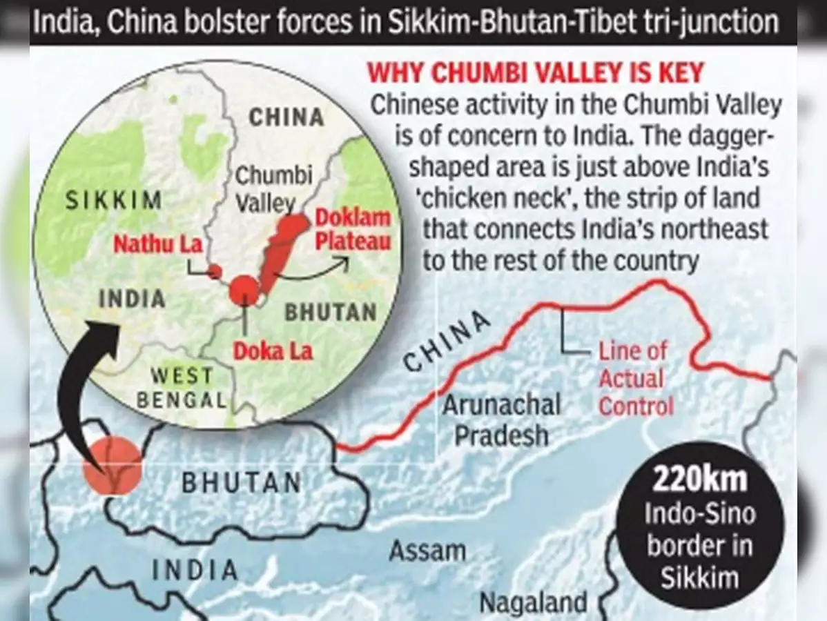
- Context:
- China is strengthening connectivity and increasing its depth in Chumbi valley in the Tibet Autonomous Region (TAR), close to India’s strategic and vulnerable Siliguri corridor.
- About:
- Chumbi valley in the eastern Great Himalaya Range of the southern Tibet Autonomous Region.
- It is situated on a small south-pointing protuberance of territory between Bhutan (east) and Sikkim (west).
- The Chumbi Valley is connected to Sikkim to the southwest via the mountain passes of Nathu La and Jelep La.
- It is formed by the passage of the Amo (Torsa) River, which rises below Tang Pass and flows south into Bhutan, the valley has an average elevation of 9,500 feet (2,900 metres), forested slopes, and a pleasant climate most of the year.
- Formerly in Sikkim, Chumbi Valley became part of Tibet in 1792.
- The inhabitants of the valley are called Promowa and are of Tibetan descent.
- Extensive trade in wool, yak tails, and borax passed through the valley after British negotiations resulted in the establishment of a trade agency at Xarsingma (Yadong) and a treaty between the British and Tibet in 1904.
- The 1904 Younghusband Expedition of British India passed through the Chumbi Vally on its way to Lhasa.
- At the end of the expedition, the British took control of the Chumbi Valley in lieu of a war indemnity.
- China agreed to pay the indemnity owed by the Tibetans in three installments and the Chumbi Valley was transferred back to Tibet on 8 February 1908.
- Since 1951 the valley has been under the control of China, which continued trade with India until 1962, when a 1954 treaty between China and India over the status of Tibet expired, and a border dispute between the two countries erupted.
GUINEA

- Context:
- Guinea has long been beset by political instability. Recent unrest started after the dismissal of a senior commander in the special forces — provoking some of its highly trained members to rebel and occupy the presidential palace.
- About:
- Guinea is a country in West Africa, bordered on the west by the Atlantic Ocean.
- It’s known for the Mount Nimba Strict Nature Reserve, in the southeast.
- The sovereign state of Guinea is a republic with a president who is directly elected by the people.
- Guinea is a predominantly Islamic country, with Muslims representing 85 per cent of the population.
LAKE TANGANYIKA

- Context:
- Most internal displacement in East Africa’s Burundi due to the rise of Lake Tanganyika.
- About:
- It is the second-largest lake in eastern Africa.
- It is the longest freshwater lake in the world and the second deepest after Lake Baikal in Russia.
- The lake is shared among four countries namely Burundi, the Democratic Republic of the Congo (DRC), Tanzania and Zambia.
- It is situated on the line dividing the floral regions of eastern and western Africa, and oil palms, which are characteristic of the flora of western Africa, grow along the lake’s shores.
- The largest rivers discharging into the lake are the Malagarasi, the Ruzizi, and the Kalambo. Its outlet is the Lukuga River, which flows into the Lualaba River.
- Rice and subsistence crops are grown along the shores, and fishing is of some significance. Hippopotamuses and crocodiles abound, and the birdlife is varied.
LA PALMA VOLCANO

- Context:
- Recently, the Cumbre Vieja volcano in La Palma, one of Spain's Canary Islands, erupted.
- About:
- La Palma is the most north-westerly island of the Canary Islands, Spain.
- La Palma has an area of 708 square kilometres making it the fifth largest of the eight main Canary Islands.
- Its highest mountain is the Roque de los Muchachos, at 2,423 metres being second among the peaks of the Canaries only to the peaks of the Teide massif on Tenerife.
- The Cumbre Vieja volcano erupted for the first time in 50 years. The last time hot molten lava erupted and spread was in 1971
- Other Recently Erupted Volcanoes:
- Kilauea Volcano : Hawaii.
- Fukutoku-Okanoba Volcano : Japan
- Sangay Volcano : Ecuador
- Taal Volcano : Philippines
- Mt. Sinabung, Merapi volcano, Semeru volcano: (Indonesia).
QEQERTAQ AVANNARLEQ

- Context:
- It is a tiny, uninhabited and previously unknown island discovered recently off the coast of Greenland.
- About:
- Measuring 60×30 metres and with a peak of three metres above sea level, it has now become the new northernmost piece of land on Earth. Before this, Oodaaq was marked as the Earth’s northernmost terrain.
- Properties:
- It is made up of seabed mud and moraine, i.e. soil, rock and other material left behind by moving glaciers, and has no vegetation.
- The researchers have suggested the discovery be named ‘Qeqertaq Avannarleq’, which is Greenlandic for “the northernmost island”.
EL SALVADOR

- Context:
- El Salvador became the first country to adopt Bitcoin as legal tender. But the launch was marked by Chivo app (state-backed wallet app) glitches and a crash in the Bitcoin price.
- About:
- El Salvador, the country of Central America.
- It is the smallest and most densely populated of the seven Central American countries.
- Despite having little level land, it traditionally was an agricultural country, heavily dependent upon coffee exports.
- El Salvador is bounded by Honduras to the north and east, by the Pacific Ocean to the south, and by Guatemala to the northwest.
- Its territory is situated wholly on the western side of the isthmus, and it is, therefore, the only Central American country that lacks a Caribbean coast.
PANJSHIR VALLEY

- Context:
- Taliban forces conquered the strategically important Panjshir Valley region amidst reports that the leader of the resistance fighters Ahmad Massoud has left for a secure place outside Afghanistan.
- About:
- Panjshir valley or Valley of the Five Lions is in north-central Afghanistan
- Located 150 km north of Kabul, the Valley is near the Hindu Kush Mountain range.
- It’s divided by the Panjshir river and ringed by the Panjshir mountains in the north and the Kuhestan mountains in the south.
- The mountain tops are covered by snow throughout the year.
- This difficult terrain makes the Valley a nightmare for invaders.
- Significance:
- The Valley has repeatedly played a decisive role in Afghanistan’s military history, as its geographical position almost completely closes it off from the rest of the country.
- The only access point to the region is through a narrow passage created by the Panjshir River, which can be easily defended militarily.
- Famed for its natural defenses, the region tucked into the Hindu Kush mountains never fell to the Taliban during the civil war of the 1990s, nor was it conquered by the Soviets a decade earlier.
- Panjshir Valley was among the safest regions in the country during the time of the NATO-backed government from 2001 to 2021.
- The valley is also known for its emeralds, which were used in the past to finance the resistance movements against those in power.
BAGRAM AIRFIELD

- About:
- Bagram Airfield-BAF, also known as Bagram Air Base, was the largest U.S. military base in Afghanistan.
- It is located next to the ancient city of Bagram in the Parwan Province of Afghanistan.
- Other important bases in Afghanistan:
- Marine Corps Base in Delaram province.
- Camp Leatherneck Marine in Helmand Province
- Camp Dwyer Marine Base in Hemland River Valley
- Shindand Air Base in Herat Province
SOUTH CHINA SEA

- Context:
- Recently, China has notified new maritime rules, warranting vessels to report their information when passing through what China sees as its“Territorial Waters”, that will take effect from 1st September 2021.
- It may lead to increased tensions if Beijing strictly enforces them in the disputed South China Sea.
- About:
- South China Sea is an arm of western Pacific Ocean in Southeast Asia.
- It is south of China, east & south of Vietnam, west of the Philippines and north of the island of Borneo.
- It is connected by Taiwan Strait with the East China Sea and by Luzon Strait with the Philippine Sea.
- It contains numerous shoals, reefs, atolls and islands.
- The Paracel Islands, the Spratly Islands and the Scarborough Shoal are the most important.
- Bordering states:
- People’s Republic of China, the Republic of China (Taiwan), Philippines, Malaysia, Brunei, Indonesia, Singapore and Vietnam.
- Significance:
- Strategic importance:
- This sea holds tremendous strategic importance for its location as it is the connecting link between the Indian Ocean and the Pacific Ocean. (Strait of Malacca)
- Trade route:
- According to the United Nations Conference on Trade And Development (UNCTAD) one-third of the global shipping passes through it, carrying trillions of trade which makes it a significant geopolitical water body.
- Biodiversity:
- This sea has one-third of the entire world’s marine biodiversity and contains lucrative fisheries providing food security to the Southeast Asian nations.
- Oil reserves:
- South China Sea is believed to have huge oil and gas reserves beneath its seabed.
ALGERIA

- Context:
- Wildfires in the forested mountains of northern Algeria have killed at least 65 people.
- About:
- Algeria is a country in North Africa on the Mediterranean coast
- Its capital and most populous city Algiers is a gateway between Africa and Europe and has been battered by violence over the past half-century.
- It has a long Mediterranean coastline.
- About 90% of Algerians live in the northern, coastal area
- Algeria is the second largest country in Africa, and the tenth largest country in the world.
- The northern portion, an area of mountains, valleys, and plateaus between the Mediterranean Sea and the Sahara Desert.
- Algeria has the fifth-largest reserves of natural gas in the world and is the second largest gas exporter; it ranks fourteenth for oil reserves.
HONG KONG

- Context:
- Recently, China has passed a wide-ranging new security law for Hong Kong which makes it easier to punish protesters and reduces the city's autonomy.
- About:
- Officially the Hong Kong Special Administrative Region of the People's Republic of China (HKSAR), Hong Kong is a metropolitan area and special administrative region of China.
- It is located in the eastern Pearl River Delta by the South China Sea.
- It was a British colony after the Qing Empire ceded the Island at the end of the First Opium War in 1841 then again in 1842
- It remained under British control until 1997.
- Afterwards, the territory was returned to China.
- Hong Kong is a highly developed territory and is one of the most densely populated places in the world.
- The territory has become one of the world's most significant financial centres and commercial ports.
- It is the world's tenth-largest exporter and ninth-largest importer
- Hong Kong has a major capitalist service economy characterised by low taxation and free trade
- Hong Kong maintains separate governing and economic systems from that of mainland China under a principle of “one country, two systems”.
- It operates as a separate currency, customs territory, border controls and has a free port.
- Hence, no tariffs are charged on the import or export of goods.
- Sino-British Joint Declaration:
- It is a treaty signed between the United Kingdom and China in 1985 on Hong Kong under Chinese sovereignty.
- According to the treaty, China would reassume control of Hong Kong in 1997.
- It stated that China's basic policies regarding Hong Kong “will remain unchanged for 50 years” and ensured a high degree of autonomy to Hong Kong.
- These policies are stipulated in the Basic Law, the city’s mini-constitution.
- Under the Basic Law – the Constitution that has governed Hong Kong since 1997 the HKSAR is a part of China but enjoys “a high degree of autonomy” and “executive, legislative and independent judicial power”, except in foreign policy and defence.
- It also says “the socialist system and policies shall not be practised” in Hong Kong for 50 years.
- In short, the document affirms the principle of “one country, two systems”.
- Recent crisis:
- China has recently started pushing for an improvement in the ‘Basic Law’ signalling a fundamental change in the way the Hong Kong is run.
- Since the British handover of Hong Kong to China, Hong Kong residents have time and again taken to the streets to protect their Basic Law freedoms, with the first major pro-democracy protest taking place in 2003.
- The largest protests since the 1997 handover took place in 2019, when for months tens of thousands of Hong Kongers agitated against a proposed extradition law, and continued with pro-democracy marches.
- Chinese response:
- Under Article 23 of the Basic Law, Hong Kong was always meant to have a security law, but could never pass one because it was so unpopular.
- On 30 June 2020, China introduced the National Security Law (NSL) in Hong Kong in response to massive pro-democracy protests.
- The controversial law reduces Hong Kong's judicial autonomy and makes it easier to punish demonstrators and activists.
- Beijing insists that the law is needed to bring stability to the city, but critics say it violates the “one country, two systems” principle under which the former British colony was handed back to China.
- The new China-imposed security law and an official campaign dubbed “Patriots rule Hong Kong” has since criminalised much dissent and strangled the democracy movement.
HAITI

- Context:
- Haiti’s President was recently assassinated.
- About:
- Haiti is a country located on the island of Hispaniola in the Greater Antilles archipelago of the Caribbean Sea, to the east of Cuba and Jamaica and south of The Bahamas.
- It occupies the western three-eighths of the island which it shares with the Dominican Republic.
- It is the third largest country in the Caribbean by area, and has an estimated population of 11.4 million, making it the most populous country in the Caribbean.
- History:
- The island was a colony and the French established lucrative sugarcane plantations, worked by vast numbers of slaves brought from Africa, which made the colony one of the richest in the world.
- In the midst of the French Revolution (1789–99), slaves and free people of color launched the Haitian Revolution (1791–1804), led by a former slave and the first black general of the French Army, Toussaint Louverture.
- After 12 years of conflict, Napoleon Bonaparte's forces were defeated by Louverture's successor, Jean-Jacques Dessalines (later Emperor Jacques I), who declared Haiti's sovereignty on 1 January 1804—the first independent nation of Latin America and the Caribbean, the second republic in the Americas, the first country to abolish slavery, and the only state in history established by a successful slave revolt.
CUBA

- Context:
- Cuba is witnessing its biggest anti-government protests in 30 years.
- About:
- Cuba is an island located in the northern Caribbean where the Caribbean Sea, Gulf of Mexico and Atlantic Ocean meet.
- Havana is the largest city and capital of Cuba.
- Since 1965, the state has been governed by the Communist Party of Cuba.
- Cuba is a sovereign state and a founding member of the United Nations, the G77, the Non-Aligned Movement and Organization of American States.
- Sugar is the country’s primary export good and the country produces over 5 million tons a year.
IRAQ AND SYRIA

- Geography:
- The region is drained by two rivers – Euphrates and Tigris – both of which drain Ira and only Euphrates draining Syria.
- Both of them originate in the mountains of Turkey.
- Iraq:
- Neighbours of Iraq – Turkey to the north, Iran to the east, Kuwait to the southeast, Saudi Arabia to the south, Jordan to the southwest and Syria to the west.
- It has a coastline on the Northern Persian Gulf.
- Important location:
- Mosul – Located on the west bank of the Tigris, Mosul was under ISIS control until liberated by coalition forces in 2016.
- Erbil/Irbil – It is the capital city of Iraqi Kurdistan.
- Kirkuk, Fallujah and Tikrit are other major towns in Iraq.
- Syria:
- Neighbours of Syria: Lebanon to the southwest, the Mediterranean Sea to the west, Turkey to the north, Iraq to the east, Jordan to the south, and Israel to the southwest.
- Capital: Damascus
- Important location:
- Aleppo, Raqqah, Idlib and Ghouta are major towns in Syria.
AFGHANISTAN

- Context:
- The Taliban have seized power in Afghanistan two weeks before the U.S. was set to complete its troop withdrawal after a two-decade war.
- About:
- Afghanistan is a landlocked mountainous country located within South Asia and Central Asia.
- The region centered at Afghanistan is considered the “crossroads of Asia”, and the country has had the nickname Heart of Asia
- The geography in Afghanistan is mostly mountainous and rugged
- It is dominated by the Hindu Kush range, the western extension of the Himalayas that stretches to eastern Tibet via the Pamir Mountains and Karakoram Mountains in Afghanistan's far north-east.
- Afghanistan is bounded by seven different countries:
- Pakistan (longest boundary),
- India (through PoK)
- Tajikistan
- Turkmenistan
- Iran
- China (shortest border)
- Uzbekistan
- Afghanistan has an estimated population of 4.6 million composed mostly of ethnic Pashtuns, Tajiks, Hazaras, and Uzbeks.
- Important places
- Durand Line:
- The Durand Line is the 2,430-kilometre international border between Pakistan and Afghanistan.
- Wakhan Corridor:
- The Wakhan Corridor, wedged between the Pamir Mountains to the north and the Karakoram Range to the south, is a narrow strip of territory in northeastern Afghanistan that extends to China and separates Tajikistan from Pakistan.
- India shares border with this region.
- Durand Line:
- Indian investment in Afghan
- Zaranj-Delaram highway:
- This is an India financed Highway in Afghanistan, which connects the Garland Highway, linked to all Afghan cities, to Chabahar port in Iran and provides Afghanistan stable access to regional markets.
- Salma Dam:
- It is a hydroelectric and irrigation dam project located on the Hari River in Herat Province in western Afghanistan.
- Since this project is funded and constructed by the Government of India, the then Afghan cabinet renamed the Salma Dam to the Afghan-India Friendship Dam
- Power transmission line from Pul-e-Khumri to Kabul
- The Pul-e-Khumri to Kabul transmission line in Afghanistan is a 202km- long double-circuit line which is funded by the Government of India under its assistance package for power generation and transmission in Afghanistan.
- Afghanistan Parliament:
- The Afghan Parliament in Kabul was built by India at $90 million.
- It was inaugurated in 2015 and it was a gift from India to the war-ravaged nation.
- The contract was awarded to an Indian infrastructure company in 2008
- INSTC trade route:
- International North-South Transport Corridor is a 7,200-km-long multi-mode transport project for moving freight among India, Iran,Afghanistan, Armenia, Azerbaijan, Russia, Central Asia and Europe.
- Recently, in March 2021, India proposed the inclusion of Chabahar port in the INSTC route, with Jaishankar expressing hope that member states involved with the INSTC will agree on expanding membership of this project.
- Zaranj-Delaram highway:

- Major cities:
- The only city in Afghanistan with over 1 million population is its capital, Kabul.
- The rest are smaller cities and towns.
- When the Taliban seized power in 1996 >> capital of the country was transferred to Kandahar.

ALPS

- Context:
- Climate change has dramatically altered the Swiss Alp landscape—at a quicker pace than expected—as melting glaciers have created more than 1,000 new lakes across the mountains.
- About:
- Alps is a mountain chain that stretches across a large part of Western Europe.
- The Alps form part of France, Italy, Switzerland, Germany, Austria, Slovenia, Croatia, Bosnia and Herzegovina, Montenegro, Serbia, and Albania.
- However, only Switzerland and Austria can be considered true Alpine countries.
- They are the most prominent of western Europe’s physiographic regions.
- The mountains were formed over tens of millions of years as the African and Eurasian tectonic plates collided and formed into these fold mountains.
- The Alpine crests isolate one European region from another and are the source of many of Europe’s major rivers, such as the Rhône, Rhine, Po, and numerous tributaries of the Danube.
- Because of their arc like shape, the Alps separate the marine west-coast climates of Europe from the Mediterranean areas of France, Italy, and the Balkan region.
- Mont Blanc at 4,807 metres is the highest peak in the Alps and is located on the French-Italian Border.
TAIWAN

- Context:
- Recently Taiwan has come under increased military and political pressure from Beijing to accept its sovereignty, but Taipei has pledged to defend their freedom and that only Taiwan's people can decide their future.
- China's air force mounted four straight days of incursions into Taiwan's air defence zone from October 1, involving close to 150 aircraft.
- The USA has reaffirmed its support for Taiwan following China's incursions
- About:
- Taiwan, officially the Republic of China (ROC), is an island state in East Asia.
- Neighboring states include the People's Republic of China (PRC) to the west, Japan to the north-east, and the Philippines to the south.
- Taipei is the capital and largest metropolitan area.
- The political status of Taiwan remains uncertain.
- People's Republic of China (PRC) claims Taiwan as part of territory of China which will be eventually reunified.
- PRC refuses diplomatic relations with countries that recognize the ROC/Taiwan.
- Taiwan is a member of the World Trade Organization, Asia-Pacific Economic Cooperation and Asian Development Bank under various names like Chinese Taipei.
- History:
- China and Taiwan separated amid civil war in 1949 and China considers Taiwan part of its territory to be taken control of by force if necessary.
- But Taiwan's leaders say that Taiwan is a sovereign state.
- After decades of hostile intentions and angry rhetoric, relations between China and Taiwan started improving in the 1980s.
- China put forward a formula, known as “one country, two systems”, under which Taiwan would be given significant autonomy if it accepted Chinese reunification.
- Taiwan rejected the offer, but the government did relax rules on visits to and investment in China.
- Beijing considers Taiwan's Republic of China (ROC) government is illegitimate >> and hence government-to-government contact does not happen.
- But there were some talks between the two sides' unofficial representatives.
- China's implementation of a national security law in Hong Kong in 2020 >> makes Taiwan more suspicious of China’s increasing assertiveness.
- One-China policy:
- ‘One-China policy’ is a policy saying that there is only one sovereign state under the name China, despite the fact that there are two states, the People's Republic of China (PRC) and the Republic of China (ROC).
- While most countries acknowledge this policy, and does not recognize an independent Taiwan, they also establish unofficial diplomatic relations with Taiwan’s government.
AGALEGA ISLANDS

- Context:
- Mauritius denies report that it allowed India to set up military base on Agalega island
- About:
- Agalega Islands are two outer islands of Mauritius located in Indian Ocean, about 1,000 kilometres north of Mauritius island.
- The population of the Islands was estimated at 300.
- MoU between the governments of Mauritius and India was signed in 2015 for setting up and upgradation of infrastructure in Agalega island for improving sea and air connectivity
- The project was a part of India’s SAGAR (Security And Growth for All in Region) Project
- The Agalega area is currently a blind spot for the Indian Navy and by building a military facility in it, India hoped to expand its maritime domain awareness.
KALAPANI

- Context:
- Recently Nepal reiterated its position that “Kalapani in Uttarakhand is part of Nepal’s sovereign territory”.
- Nepal has raised the Kalapani boundary dispute during the recent Joint commission meeting with India in 2018.
- Dispute intensified in November 2019, when India published a revised political map after the reorganization of J&K, depicting Kalapani as the region of India.
- Nepal immediately issued an objection to the map. Nepal government released a map mentioning Kalapani -Lipulekh- Limpiyadhura as a territory of the Darchula district of Sudurpashchim province of Nepal.
- Recently Nepal reiterated its position that “Kalapani in Uttarakhand is part of Nepal’s sovereign territory”.
- About:
- Kalapani is a valley that is administered by India as a part of the Pithoragarh district of Uttarakhand.
- It is situated on the Kailash Mansarovar route.
- The Kali River in the Kalapani region demarcates the border between India
- and Nepal.
- The Treaty of Sugauli signed by the Kingdom of Nepal and British India (after Anglo-Nepalese War) in 1816 located the Kali River as Nepal's western boundary with India.
- The discrepancy in locating the source of the river led to boundary disputes between India and Nepal, with each country producing maps supporting their own claims.
- Strategic significance:
- Kalapani is located at the China-Nepal-India tri-junction and is a strategically important area.
- So Kalapani was regarded as an ‘observation zone’ for troops. For example, by stationing Indian troops at Kalapani, India can observe the movement of the Chinese troops and push them back if required.
- Since 1962, Kalapani has been guarded by the Indian security forces.
- Kali river:
- Kali River/ Sharda River/Mahakali River originates at Kalapani in Uttarakhand.
- It flows along Nepal's western border with India
- It joins Ghaghra River, a tributary of the Ganges
- Hydroelectric projects in the river: Tanakpur hydro-electric project, Chameliya hydro-electric project and Sharda Barrage.
KYRGYSTAN

- Context:
- India extends USD 200 million Line of Credit to support development projects in Kyrgyzstan.
- About:
- Kyrgyzstan is a country in Central Asia. It's the second smallest of the five Central Asian states of Kazakhstan, Kyrgyzstan, Tajikistan, Turkmenistan, and Uzbekistan.
- Part of Soviet Union occupied, Kyrgyzstan attained sovereignty as a nation-state only after the breakup of the Soviet Union in 1991.
- It is bordered by four countries: Kazakhstan to the north, Uzbekistan to the west and southwest, Tajikistan to the southwest and China to the east.
- Its capital and largest city is Bishkek.
- Strategic significance:
- For China:
- This landlocked Central Asian country that shares a long border with China.
- It is located at the centre of Eurasia, is a vital link in its Belt and Road Initiative.
- China has built road and rail networks with Kyrgyzstan and Uzbekistan.
- For Russia
- Russia considers the region as its backyard and plays hard politics to retain its influence.
- Kyrgyzstan is a member of the Russia-led Collective Security Treaty Organisation (CSTO).
- CSTO is a Russia-led military alliance of six former Soviet states that was created in 2002.
- Its aim is to ensure the collective defence of any member that faces external aggression.
- For USA:
- During the early stages of the Afghan war, the USA had used Kyrgyzstan for refuelling and other logistical purposes.
SUDAN

- Context:
- Sudan's military takes power in coup, arrests Prime Minister Hamdok.
- Since its independence from the British and Egyptian Colonial Rule in 1956, Sudan has seen famines, sectarian violence, and political crisis.
- Almost three years ago, tens of thousands of Sudanese rose against the regime of Omar al-Bashir in what they call a “revolution” that eventually led to the dictator’s fall in 2019.
- Ever since, the military and leaders of the civilian movement came together to form a transitional government.
- However recent coup by Sudan’s military has thrown the African country’s fragile transition from dictatorship to democracy into chaos.
- About:
- Sudan is situated in northern Africa, with a coastline bordering the Red Sea.
- It has land borders with Egypt, Eritrea, Ethiopia, South Sudan, the Central African Republic, Chad, and Libya.
- The Blue Nile and White Nile rivers meet in Khartoum (Capital of Sudan) to form the Nile, which flows northwards through Egypt to the Mediterranean Sea.
- Sudan is a member of the United Nations, the Arab League, African Union, COMESA, Non-Aligned Movement and the Organisation of Islamic Co- operation.
- Darfur region:
- The region was recently in news due to conflict between the nation’s dominant Arab rulers and the African ethnic communities demanding greater autonomy.
- Over 60 people were massacred in Sudan’s Darfur region in 2020.
- About 500 armed men targeted the Masalit community in west Darfur’s Masteri town.
UKRAINE

- About:
- Ukraine, a country located in eastern Europe.
- The capital is Kyiv (Kiev), located on the Dnieper River in north-central Ukraine.
- Ukraine is bordered by Belarus to the north, Russia to the east, the Sea of Azov and the Black Sea to the south, Moldova and Romania to the southwest, and Hungary, Slovakia, and Poland to the west.
- In the far southeast, Ukraine is separated from Russia by the Kerch Strait, which connects the Sea of Azov to the Black Sea.
- History:
- With the dissolution of the U.S.S.R. in December 1991, Ukraine gained full independence.
- The country changed its official name to Ukraine, and it helped to found the Commonwealth of Independent States (CIS), an association of countries that were formerly republics of the Soviet Union.
- Recent Issues:
- Recently, Ukraine got at loggerheads with Russia over the occupation of Crimean peninsula by Russia in 2014.
- In June 2020, Ukraine became ‘Enhanced Opportunity Partners’ under the Partnership Interoperability Initiative of North Atlantic Treaty Organization (NATO).
- Ukraine is also seeking European Union and NATO membership, a move that could obstruct attempts to resolve other tensions with Russia.
SOLOMON ISLANDS

- Context:
- Australia sends troops to the Solomon Islands, where anti-government protesters took to the streets in the capital, Honiara, for a second day running in defiance of a lockdown order.
- About:
- Is a sovereign country consisting of six major islands and over 900 smaller islands in Melanesia.
- Melanesia is a subregion of Oceania in the southwestern Pacific Ocean
- Its capital, Honiara, is located on the largest island, Guadalcanal
- Geographical features:
- Archipelago of mountains, heavily forested volcanic islands (some active) and few low lying coral atolls.
- Chinese influence:
- In 2019, a Beijing-based company which has close ties to the Chinese Communist Party has secured exclusive development rights for the entire island of Tulagi and its surroundings.
- Tulagi is an island within the Solomon Islands
- The Solomons cut ties to Taiwan and allied with Beijing just a few days before the Tulagi deal
- The Solomon Islands are located directly between Australia and the U.S. and was the site of fierce battles during World War II.
- Solomon Islands campaign (1942–1945) saw fierce fighting between the United States, Commonwealth forces and the Empire of Japan.
- Is a sovereign country consisting of six major islands and over 900 smaller islands in Melanesia.
ENGLISH CHANNEL

- Context:
- Top European migration officials held an emergency meeting Sunday in the French port of Calais to find ways to better fight migrant smuggling, after 27 people died trying to cross the English Channel to Britain in an overcrowded inflatable boat.
- About:
- It is an arm of the Atlantic Ocean that separates Southern England from northern France and links to the southern part of the North Sea by the Strait of Dover at its northeastern end.
- With an area of some 29,000 square miles (75,000 square km), it is the smallest of the shallow seas covering the continental shelf of Europe.
- The water is rich in warm- and cold-water plankton.
- The Channel was a key factor in Britain becoming a naval superpower and has been utilised by Britain as a natural defence mechanism through which they halted many would-be invasions, such as the Napoleonic Wars and those of Adolf Hitler in World War II.
PORT OF LATAKIA

- Context:
- An Israeli air strike hit a shipment of Iranian weapons in the Syrian port of Latakia on 7th December 2021.
- About:
- The Port of Latakia is a seaport, located on the Mediterranean sea in the city of Latakia.
- Established in 1950, it has since served as Syria's main seaport.
- Iran is preparing to take control of Syria’s main commercial port, advancing its plans to secure a trade route from Tehran to the Mediterranean and establishing a significant foothold on Israel’s doorstep.
GOLAN HEIGHTS

- Context:
- Israel approves plan to double settlers in occupied Golan Heights.
- About:
- The Golan Heights is a rocky plateau on the border between Israel and Syria in south-western Syria.
- Geographically, the Golan is bounded by the Jordan River and the Sea of Galilee on the west, Mount Hermon on the north, the seasonal Wadi Al-Ruqqad river on the east, and the Yarmuk River on the south.
- Importance:
- The Golan Heights give Israel an excellent point for monitoring Syrian movements.
- The topography provides a natural buffer against any military adventure from Syria.
- The area is also a key source of water for an arid region. Rainwater from the Golan's catchment feeds into the Jordan River.
- The area provides a third of Israel's water supply.
- The land is fertile, and the volcanic soil is used to cultivate vineyards and orchards and raise cattle.
- History:
- After World War I the Golan became part of the French mandate of Syria and in 1941 passed to independent Syria.
- After the Arab-Israeli War of 1948–49, Syria fortified the western crest of the Golan Heights, which commands the Ḥula Valley, the Sea of Galilee, and the upper Jordan River valley, all in Israel.
- Israel occupied the Golan Heights, West Bank, East Jerusalem, and the Gaza Strip in the 1967 Six-Day War.
- An armistice line was established and the region came under Israeli military control.
- Syria tried to retake the Golan Heights during the 1973 Middle East war. Syria was defeated in its attempt.
- Both countries signed an armistice in 1974 and a UN observer force has been in place on the ceasefire line since 1974.
- Israel unilaterally annexed the Golan Heights in 1981. The move was not recognised internationally, although the US Trump Administration did so unilaterally in March 2019.
- The international community regards as disputed territory occupied by Israel whose status should be determined by negotiations between Israel and Syria.
TRINCOMALEE OIL TANK FARM

- Context:
- Sri Lanka to ink three new lease agreements to develop Trincomalee oil tank farm with India.
- It is a coveted project that has remained controversial since long time.
- About:
- The Trincomalee Oil Tank Farm is located in ‘China Bay’, in close proximity to the internationally coveted deep water natural harbour of Trincomalee.
- It comprises of 99 storage tanks, with a capacity of 12,000 kilolitres each, spread across Lower Tank farm and Upper Tank Farm.
- Currently, Lanka IOC (a subsidiary of Indian Oil Corporation) runs 15 tanks.
- The new agreement is being negotiated for the remaining tanks.
- Indian Oil Corporation will work with the Ceylon Petroleum Corporation for developing the Upper Tank Farm.
- Tricomalee also known as Gokanna/Gokarna is a major resort port city of Eastern Province, Sri Lanka.
- Trincomalee harbour being the second deepest natural harbour in the world, the British who were in control of the island decided make this as their primary logistics station in the east after World War I.
- During the Second World War, the British built the Trincomalee oil tank farms to serve as a refuelling station, adjacent to the Trincomalee port, an enviable natural harbour.
- During the World War II, the Japanese attacked Trincomalee harbour in 1942, but they couldn’t succeed in destroying it.
- The Oil Tank Farm of Trincomallee was never used in full capacity after their independence.
- The nearly century-old oil tanks need to be refurbished — at the cost of millions of dollars — if they are to be fit for use again.
RIFT VALLEY LAKES

- Context:
- The water levels of lakes in Kenya’s Great Rift Valley increased significantly, hurting local communities and biodiversity. Climate change, human activities and an active tectonic belt are to blame for this crisis, according to a new report.
- Great Rift Valley:
- The Great Rift Valley is a series of contiguous geographic trenches, approximately 7,000 kilometres in total length, that runs from the Beqaa Valley in Lebanon which is in Asia to Mozambique in Southeast Africa.
- It is a merging of separate though related rift and fault systems.
- The divergent plate boundary extends from the Afar Triple Junction southward across eastern Africa and is in the process of splitting the African Plate into two new separate plates.
- Rift Valley Lakes:
- The Rift Valley lakes are a series of lakes in the East African Rift valley that runs through eastern Africa from Ethiopia in the north to Malawi in the south and includes the African Great Lakes in the south.
- These include some of the world's oldest lakes, deepest lakes, largest lakes by area, and largest lakes by volume.
- The World Wide Fund for Nature has designated these lakes as one of its Global 200 priority ecoregions for conservation.
STRAIT OF HORMUZ

- Context:
- American B-1B bomber flies over the Strait of Hormuz amid Iran tensions.
- About:
- It is the waterway that separates Iran and Oman, linking the Gulf to the Gulf of Oman and the Arabian Sea.
- On the north coast lies Iran, and on the south are the UAE and Musandam, an enclave of Oman.
- The Strait is 21 miles (33 km) wide at its narrowest point, but the shipping lane is just two miles (three km) wide in either direction.
DURAND LINE

- Context:
- The fence erected by Pakistan along the 2,640-km Durand Line which is opposed by the Taliban is a potential flashpoint in relations between the Taliban and Pakistan.
- About Durand Line:
- Established in the Hindu Kush in 1893, it runs through the tribal lands between Afghanistan and British India. In modern times it has marked the border between Afghanistan and Pakistan.
- In the 19th century, Afghanistan was used as a buffer by the British against the fear of Russian expansionism to its east.
- Hence the British civil servant Sir Henry Mortimer Durand signed an agreement with Afghan ruler Amir Abdur Rahman on November 12, 1893, demarcating the Durand line.
- The line stretches from the border with China to Afghanistan’s border with Iran.
- This line demarcated the limits of Afghanistan’s and British India’s “spheres of influence” on the Afghan “frontier” with India.
- McMahon Line
- It was proposed by Colonel McMahon as the boundary between Tibet, China, and India at the Shimla Convention of 1914.
- It runs from the eastern border of Bhutan along the crest of the Himalayas until it reaches the great bend in the Brahmaputra River where that river emerges from its Tibetan course into the Assam Valley.
- Radcliffe Line
- It divided British India into India and Pakistan.
- It is named after the architect of this line, Sir Cyril Radcliffe, who was also the chairman of the Boundary Commissions.
LAMU REGION (KENYA)

- Context:
- Kenya recently launched its newest mega infrastructure project, the Lamu port, which is a part of an ambitious transport corridor between Lamu (a small archipelago north of Mombasa in Kenya), South Sudan and Ethiopia.
- About Lamu Region:
- Lamu Island is located on the eastern coast of Kenya.
- Lamu is one of the oldest and the best-preserved living settlements among the Swahili towns (in Arabic Swahili means “of the coast”) on the East African coast.
- The old town is thus a unique and rare historical living heritage with more than 700 years of continuous settlement.
- It is built on coral stone and mangrove timber and is characterized by structural forms such as inner courtyards, verandas, and elaborately carved wooden doors.
- It was one of the most important trade centres in East Africa before other towns such as Zanzibar and Mombasa took over.
- Lamu represents the Swahili culture, resulting from the interaction between the Bantu, Arabs, Persians, Indians, and Europeans.
- Lamu has hosted major Muslim religious festivals since the 19th century and has become a significant centre for the study of Islamic and Swahili cultures.
- It is recognised as a World Heritage Site by the United Nations Educational, Scientific and Cultural Organization (UNESCO).
LYNETTEHOLM

- Context:
- Recently, Denmark has approved the building of Lynetteholm, an artificial island off the coast of Copenhagen (capital of Denmark, located near the Baltic Sea).
- About:
- The 275-hectare project was designed as a housing and business district for around 35,000 people.
- It will be built using soil from construction projects in Copenhagen and the surrounding area.
- The artificial island will be located between Nordhavn and Refshaleøen.
- It will protect the city's harbour from rising water masses and from more frequent storm surges.
MOUNT KILAUEA

- Context:
- Scientists are on alert for a possible eruption of Hawaii’s Kilauea Volcano within Hawaii Volcanoes National Park.
- About:
- Kilauea, also called Mount Kilauea.
- It is located in Hawaii Volcanoes National Park on the southeastern part of the island of Hawaii, U.S.A.
- It is an active shield volcano. Historically, it is the most active of the five volcanoes that together form the Big Island of Hawaii.
- Kilauea has erupted 34 times since 1952.
NINGBO-ZHOUSHAN PORT

- Context:
- In what could potentially threaten global supply chains and impact maritime trade, China has partially shut down the world’s third-busiest container port after a worker there tested positive for Covid-19.
- About:
- The Meishan terminal at Ningbo-Zhoushan port, which is south of Shanghai, accounts for over a fourth of the container cargo handled at the Chinese port.
- Meishan terminal mainly services trade destinations in North America and Europe
ISLAND OF EVIA

- Context:
- Fire devours Greek's second-largest island; residents are urged to flee.
- About:
- It is also called Euboea, it is the second-largest Greek island in the area.
- It is separated from Boeotia in mainland Greece by the narrow Euripus Strait.
TAAL VOLCANO

- Context:
- Recently, the Philippines increased the alert level on Taal Volcano to level 3 on a five-level scale after a Phreatomagmatic Eruption (PE) occurred that generated a dark greyish plume, one kilometer high.
- About:
- Situated on the island of Luzon, 50 km from Manila, Philippines.
- The Philippines is situated at the boundaries of two tectonic plates – the Philippines Sea Plate and the Eurasian plate – thus susceptible to earthquakes and volcanism.
- Taal is one of the most active volcanoes in the Philippines due to its location on the Pacific “Ring of Fire” – a zone of intense seismic activity.
- Complex Volcano:
- It is classified as a “complex” volcano by the Philippine Institute of Volcanology and Seismology (PHIVOLCS).
- A complex volcano, also called a compound volcano, is defined as one that doesn't have just one main vent or cone but several eruption points. Another such example is Mount Vesuvius on the west coast of Italy.
LAST ICE AREA (LIA)

- Context:
- The ‘Last Ice Area’ (LIA), located in the Arctic’s ice north of Greenland has started melting earlier than scientists had expected.
- About:
- This region is located north of Greenland and Ellesmere Island in the Canadian territory of Nunavut.
- This area was believed to be strong enough to withstand global warming.
- The total disappearance of summer ice in the Arctic was estimated by the year 2040, however the 'Last Ice Area’ was the exception.
CABO DELGADO

- Context:
- The European Union has approved a Military Training Mission in Mozambique (Cabo Delgado) to support armed forces there to protect the civilian population.
- About:
- It is the northernmost province of Mozambique.
- As well as bordering the neighbouring country of Tanzania, it borders the provinces of Nampula and Niassa.
- The region is an ethnic stronghold of the Makonde tribe, with the Makua and Mwani as leading ethnic minorities.
SANAA

- Context:
- A Saudi-led military coalition mounted airstrikes on Yemen’s Houthi-controlled capital Sana’a after it intercepted 10 drones launched by the Iran-backed rebels.
- About:
- Sanaa also spelt Sanaʽa or Sana, is the largest city in Yemen.
- Under the Yemeni constitution, Sanaʽa is the capital of the country, although the seat of the Yemeni government moved to Aden, the former capital of South Yemen in the aftermath of the Houthi occupation.
- Aden was declared as the temporary capital by President Abdrabbuh Mansur Hadi in March 2015.
- It is located next to the Sarawat Mountains of Jabal An-Nabi Shu'ayb and Jabal Tiyal, considered to be the highest mountains in the country and amongst the highest in the region.
- The Old City of Sanaʽa, a UNESCO World Heritage Site, has a distinctive architectural character, most notably expressed in its multi-story buildings decorated with geometric patterns.
LIVERPOOL

- Context:
- Liverpool has been stripped of its World Heritage status after a UN committee found developments threatened the value of the city’s waterfront.
- About:
- Liverpool is a city on the banks of the River Mersey in England.
- The decision was made following a secret ballot by the UNESCO Committee at a meeting in China.
- UNESCO had previously warned that the developments, including the new Everton FC stadium, had resulted in a “serious deterioration” of the historic site.
- The city was awarded the much-coveted title in 2004 in recognition of its historical and architectural impact, joining places including the Taj Mahal, Egypt’s Pyramids and Canterbury Cathedral.
CALI
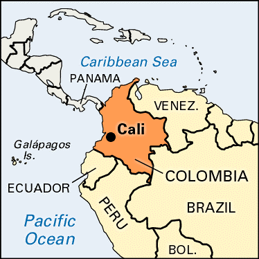
- Context:
- The Colombian Army has tightened its control over Cali following the latest anti-government protests.
- About:
- Cali is the second-largest city in Colombia by area and the third most populous.
- It is the only major Colombian city with access to the Pacific Coast.
- Cali is located in the Cauca Valley to the west of the Cauca River.
SAINT VINCENT AND THE GRENADINES

- Context:
- Cabinet approved the agreement between India and Saint Vincent and The Grenadines for the Exchange of Information and Assistance in Collection with respect to Taxes.
- About:
- It is an island country in the Caribbean.
- It is located in the southeast Windward Islands of the Lesser Antilles, which lie in the West Indies at the southern end of the eastern border of the Caribbean Sea where the latter meets the Atlantic Ocean.
VORUKH

- Context:
- Kyrgyzstan said at least 31 people have been killed in heavy clashes at its disputed border with Tajikistan, as officials from the two ex-Soviet countries met in a bid to defuse tensions.
- About:
- Vorukh is a jamoat in northern Tajikistan. It is an exclave surrounded by Kyrgyzstan that forms part of the city of Isfara in Sughd Region.
- The location of the border of the enclave is disputed by the Tajik and Kyrgyz governments.
- More than a third of the two impoverished, mountainous countries’ border is disputed, with the area surrounding the Vorukh, where recent conflict erupted, a regular flashpoint over territorial claims and access to water.
- In April and May 2021, the region once again brought tensions between the two countries – at least 31 people were killed in ongoing fighting.
SAHEL

- Context:
- Chad, the former French colony is now the prime outpost of the West in fighting Islamist militants across the Sahel. France still has a strong military presence in the Sahel region.
- About:
- The Sahel is the ecoclimatic and biogeographic realm of transition in Africa between the Sahara to the north and the Sudanian savanna to the south.
- Having a semi-arid climate, it stretches across the south-central latitudes of Northern Africa between the Atlantic Ocean and the Red Sea.
- The Sahel part of Africa includes northern Senegal, southern Mauritania, central Mali, northern Burkina Faso, the extreme south of Algeria, Niger, the extreme north of Nigeria, the extreme north of Cameroon and the Central African Republic, central Chad, central and southern Sudan, the extreme north of South Sudan, Eritrea, and the extreme north of Ethiopia.
WHITSUN REEF

- Context:
- China’s aggressive expansion in the South China Sea has found a new ground, Whitsun Reef, where 220 Chinese vessels are currently anchored under the Philippines’ Exclusive Economic Zones (EEZ).
- About:
- Whitsun Reef, also known as Whitson Reef, Whitsum Reef, and Julian Felipe Reef
- It is a reef at the northeast extreme limit of the Union Banks in the Spratly Islands of the West Philippine Sea.
- It is the largest reef of the Union Banks.
DOOMSDAY GLACIER

- Context:
- Researchers at Sweden’s University of Gothenburg are now saying that fears related to the melting of Antarctica’s Thwaites Glacier are worse than previously thought, owing to the supply of warm water flowing underneath at a rate underestimated in the past.
- About:
- Also called the Thwaites Glacier, it is located in Antarctica.
- The Thwaites Glacier is 120 km wide at its broadest, fast-moving, and melting fast over the years.
- Because of its size (1.9 lakh square km), it contains enough water to raise the world sea level by more than half a metre. Studies have found the amount of ice flowing out of it has nearly doubled over the past 30 years.
- Today, Thwaites’s melting already contributes 4% to global sea-level rise each year. It is estimated that it would collapse into the sea in 200-900 years.
- Thwaites is important for Antarctica as it slows the ice behind it from freely flowing into the ocean. Because of the risk it faces — and poses — Thwaites is often called the Doomsday Glacier.
VALLEY OF THE FALLEN

- Context:
- Recently, the Spanish government has kick-started the process to open up a mass grave at the ‘Valley of the Fallen’, where over 30,000 victims of the Spanish Civil War lay buried.
- About:
- The Valle de los Caídos or Valley of the Fallen is built on the slopes of a mountain range on the outskirts of Madrid.
- It was constructed by former dictator Francisco Franco following the Spanish Civil war (1936-1939) as a burial monument and Memorial Church.
- The valley was built in part by political prisoners of Franco’s regime over a period of 18 years.
KOWLOON PENINSULA

- Context:
- Hong Kong is set to grant a site on the western Kowloon peninsula, to China’s national security office for its permanent base in the city.
- About:
- The Kowloon Peninsula is a peninsula that forms the southern part of the main landmass in the territory of Hong Kong, alongside Victoria Harbour and facing toward Hong Kong island.
- The Kowloon Peninsula and the area of New Kowloon are collectively known as Kowloon.
- Geographically, the term “Kowloon Peninsula” may also refer to the area south of the mountain ranges of Beacon Hill, Lion Rock, Tate's Cairn, Kowloon Peak, etc.
- The peninsula covers five of the eighteen districts of Hong Kong.
- Kowloon Bay is located northeast of the peninsula.
SUEZ CANAL

- Context:
- In 2015, Egypt announced plans to further expand the Suez Canal, aiming to reduce waiting times and double the number of ships that can use the canal daily by 2023.
- Significance of the Suez Canal:
- The canal is a major source of income for Egypt’s economy, with the African country earning $5.61 billion in revenues from it in 2020.
- According to reports, nearly 50 ships pass through it every day, and it accounts for 12% of world trade Periyar River
- The Periyar River is the longest river in the state of Kerala with a length of 244 km.
- It is also known as the ‘Lifeline of Kerala’ as it is one of the few perennial rivers in the state.
- A perennial river is a channel that has continuous flow in parts of its stream bed all year round.
- Periyar River originates from the Sivagiri hills of Western Ghats and flows through the Periyar National Park.
- The main tributaries of Periyar are Muthirapuzha, Mullayar, Cheruthoni, Perinjankutti.